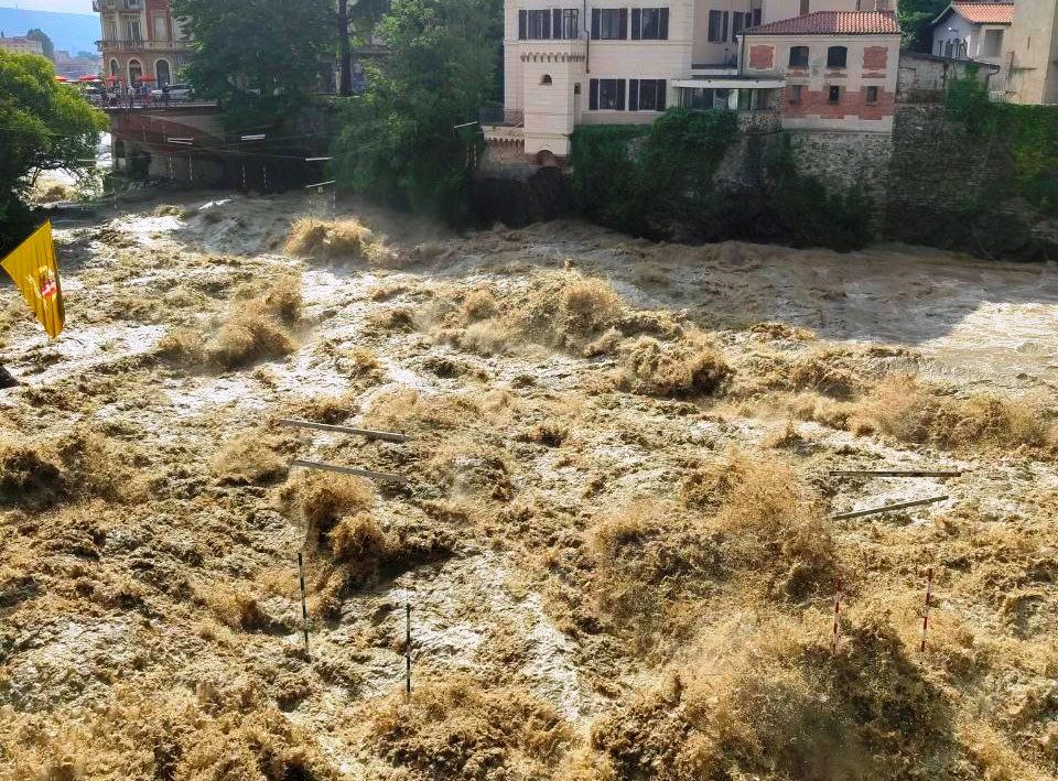
The sun is shining again Nord/Ovest scourged by a wave of bad weather of catastrophic proportions yesterday evening: between Piedmont e Valle d’Aosta it was a disaster. In less than 12 hours they fell 228mm of rain at Alpe Veglia, 176mm to Noasca, 181mm in Pecetto di Macugnaga, 178mm at the Zamboni Zappa Refuge, 153mm in Varzo, 133mm a Lillaz, 131mm in Alagna Valsesia, 128mm a Grand-Crot, 124mm at Audi Plan, 119mm a Valnontey, 117mm in Verrès, Trasquera and Larecchio, 115mm at the upper Paione Lake, 111mm in Forno Alpi Graie, 103mm at the Moro Pass, 102mm in Balme and Alpe Cheggio, 92mm a Sparone, 85mm in Formazza, 83mm to Corio, 80mm in Lanzo Torinese, 68mm in Avigliana, 67mm in Piamprato.
These are alluvial rains, which have caused very serious damage: dozens of landslides have destroyed and swept away roads, isolated villages, and grazed homes. But there were also strong winds and very large hail. Among the many images of the next day, we highlight those of Cuorgnè where in the fields, on the ground, there are holes several centimeters deep caused by the fury of the hail of yesterday evening:
The most affected areas were those of Alps e Prealps Between Piedmont central-northern e Valle d’Aosta. Fortunately there were no deaths in Italy, but things were much worse across the border: three deaths in France, two dead and one missing in Switzerland.
In Italiainstead, many evacuated, blocked, injured but fortunately at the moment there are no victims. The damage count is really impressive: gusts of wind at over 130km/h they uncovered some houses Busano:
Weather Alert: focus on bad weather in the next few hours
Bad weather, however, will return as a major protagonist in the next few hours. Once again in the North. Already this evening we will have strong thunderstorms, very intense Piedmontonce again in the Turin area, but above all in the North/East, between Trentino Alto Adige e Friuli Venezia Giuliawhile in the South it is hot but without excessive excesses:
Tomorrow, Monday 1st Julythe bad weather will intensify at Northeast: during the night and early morning we will have strong thunderstorms that will particularly affect the border areas with Austria and Slovenia.
Then, in the afternoon eveningthe most severe phase of bad weather will begin and will continue throughout the week: we will have very violent thunderstorms in the heart of the North, in Lombardy, Veneto and Emilia, and the weather will also begin to cloud over in the Centre/South where this “heat wave” very short and without excess.
Tuesday 2 July even in the South we will have heavy rains and thunderstorms.
To monitor the situation in the best possible way weather forecast in real time, below we provide a list of pages with all the useful information to follow the meteorological nowcasting minute by minute:
Below are the links for direct access to the pages with weather forecasts, particularly accurate in detail, for the geographical areas of Italy (links always reachable also from the Menu at the top of all the pages of the site):
Weather Forecast Region by Region:
Continue reading on MeteoWeb


