
reading time
5 minutes, 41 seconds
UPDATE 4.10 PM. EMILIA ROMAGNA, THE SECCHIA REACHES 11 METERS. The level of the Secchia river continues to rise, reaching 11.04 meters in Modena at the Ponte Alto station, almost equaling its historical record, now well above the red alert threshold. Also under close observation is the Tepid, also above the red threshold, whose flow, however, is showing a slight decrease in the last few hours. The bridges around Modena are still closed, awaiting the passage of the flood.
UPDATE 3.30 PM. STRONG THUNDERSTORMS ON THE EMILIAN APPENINS. The storms persist and intensify this afternoon in the Emilian Apennines, from Parma to Ravenna. In particular, a storm cell is active between Parma and Reggiano and borders on the Tuscan side, another is affecting the Forlì area between the Via Emilia and the foothills. Another strong storm is in action on the Tuscan side of the Apennines, around Pistoia.
UPDATE 2.30 PM. STRONG SHOWERS AND THUNDERSTORMS INSIST OVER THE CENTRAL-EASTERN PADANA VALLEY. During the afternoon, the flat areas of eastern Lombardy, Veneto and Emilia Romagna continue to struggle with heavy showers and thunderstorms that further complicate the hydrogeological situation. Cremonese, Bresciano, Veronese, Rodigino, Parmense and Piacentino are the areas where the most intense phenomena are recorded, but the Emilian Apennines are also affected by locally strong thunderstorms that increase the flow of the watercourses that flow towards the Po Valley.
UPDATE 1PM. EMILIA, FLOOD IN LANGHIRANO. A stream overflowed in the Langhirano area, in the Parma area, where the water reached up to a meter in height, flooding semi-underground garages and basements.
UPDATE 12.35 PM. VIOLENT THUNDERSTORMS ALONG THE COURSE OF THE PO. In addition to the tornado reported about an hour ago between Padovano and Rodigino, the entire central-eastern course of the Po is under severe storms. Lombardy, Veneto and Emilia Romagna are involved with rainfall accumulations of up to 100mm right in the Rodigino area. Critical situation in Lombardy in the Lodi area, where the Parma torrent flooded.
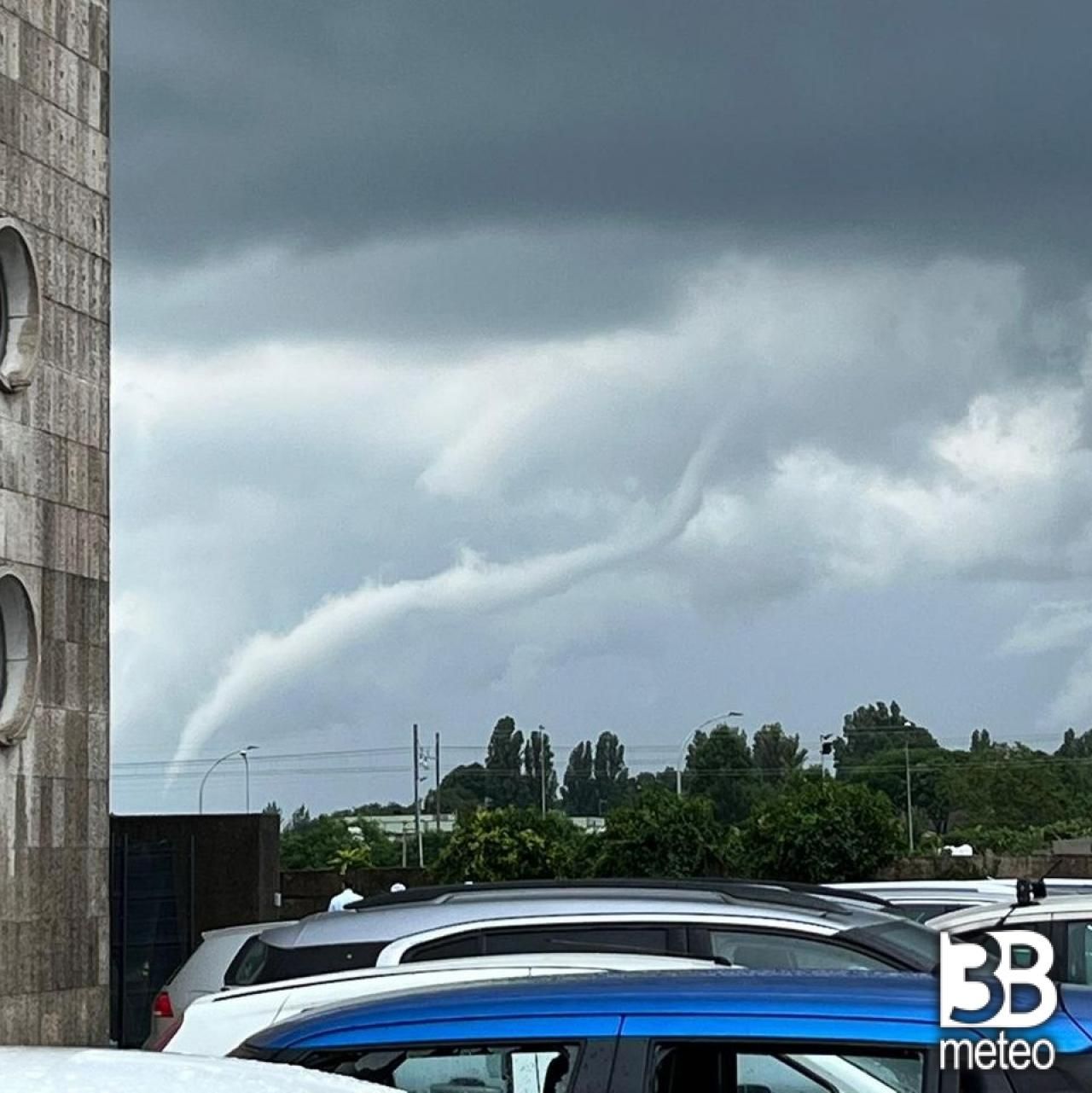
UPDATE 11.40 AM. TORNADO IN VENETO. A tornado with its typical funnel cloud was spotted between the Padua area and the Rodigino area, which touched down in an area of open countryside around 11.20 this morning. A warehouse was uncovered in the Rovigo area, there were also reports of shattered glass and collapsed ceilings in some buildings in the city. The tornado also hit the hamlets of Boara Polesine, Cantonazzo, Granzette, Lusia and Lendinara.
UPDATE 11AM. CRITICAL ISSUES IN THE PARMA AREA. The province of Parma is also dealing with the heavy wave of bad weather that is hitting the region. Rainfall accumulations vary from 20/40mm in the plain areas to 60/70mm in the Apennine areas and the flooding of some watercourses has been reported, as well as landslides which have created serious problems in Val Termina, isolating some families. Meanwhile, the Arda in Fiorenzuola has exceeded the red alert threshold.
UPDATE 9.45 AM. EMILIA, SOME BRIDGES CLOSED IN THE MODENA AREA. Due to the bad weather that gives no respite in Emilia Romagna, some bridges have been closed around Modena. The levels of the Secchia and Panaro continue to rise and both have exceeded the red alert threshold and for precautionary reasons the bridges over the Secchia river in Modena, at Ponte Alto, and the Uccellino bridge between Modena and Soliera have been closed. This morning at 7 am the roads in the Secchia area near the Campogalliano expansion tanks were also closed (Source Modena Today).
SITUATION 8 AM. The vortex located near Corsica has not made much progress compared to yesterday. Today we find it practically stationary between Corsica and the upper Tyrrhenian Sea and a disturbance unfolds from its center and is focusing on the northern regions. Rain and storms are affecting Emilia Romagna in particular, where various critical issues have been recorded with the flow rate of the waterways having increased significantly and some flooding. Bad weather also occurred in the rest of Northern Italy, as well as in Tuscany, mainly involving inland areas. Meanwhile, the rains have also reached Southern Italy, dealing with the southern branch of the same disturbance.
HYDRO-GEOLOGICAL CRITICAL ISSUES IN EMILIA ROMAGNA. This is one of the regions most affected by the bad weather in recent days, with rainfall accumulations exceeding 60mm in the Reggio Emilia area only since midnight, where the bad weather still hit hard on Monday too. The Enza is above the red alert threshold and is continuing to increase its flow, as is happening for the Crostolo, Tiepido, Secchia and Arda, all basins that descend from the Apennines full of water and which are overflowing in some places .
STORMS BETWEEN FRIULI, VENETO AND LOMBARDY. The rest of Northern Italy, in particular the Po Valley, is also dealing with bad weather linked to the same disturbance. Thunderstorms open the day between Triestino and Goriziano, showers and thunderstorms also in the lower Veneto and in Lombardy on the Mantua area, rains and showers also in Piedmont and in the Levante Ligure.
THE RAINS REACH THE SOUTH. Rain and showers reached the thirsty southern regions, mainly affecting Sicily and Calabria. The most intense phenomena affected the Messina hinterland during the night, with rainfall accumulations of around 15mm.
WEATHER FOR THE NEXT HOURS. To the North rain and showers, even thunderstorms, will affect mainly Emilia Romagna, Lombardy, Liguria, Veneto and Friuli VG, also of strong intensity with local cloudbursts and possible further hydro-geological criticalities. Initially the Alps will be less involved, but between the afternoon and the evening the rain and showers will intensify, especially in the central-eastern sectors. Weaker phenomena in Piedmont. Center marked instability in Tuscany, especially in the northern internal areas, with showers and thunderstorms, including strong ones, and possible storms, gradually easing in the evening. Initially drier elsewhere but with increasing instability from the afternoon on inland areas and the formation of showers and local thunderstorms on Umbria and Marche, spilling over to the coast. Drier and clearer weather in Lazio and Abruzzo. To the South rain easing between morning and afternoon in Sicily and Calabria with a tendency to clearing, but some showers will arrive in Basilicata, Campania and upper Puglia, even thunderstorms by evening in inland areas. In Sardinia initial clearings, tendency to variability from the afternoon on the internal areas with some showers in local border crossing to the Tyrrhenian coast. For all the details enter the section Italy weather.
Follow us on Google News


