Bologna, 30 June 2024 – A few hours of respite from the bad weather, suffocated by Saharan sand and from theafa and it’s already time to go back toWeather Alert (yellow) for the temporal. It is a very strange summer that we are experiencing: and fortunately the storms have granted a respite at least for the historic passage of the Tour de France in Emilia Romagna.
Weather alert for thunderstorms in Emilia Romagna: where are the areas at risk of cloudbursts
Weather alert also in Veneto
The problems, understood as heavy rain, will begin – reports Arpa Emilia Romagna – from the afternoon of Monday 1 July. “Conditions favorable to the development of. are expected – the forecasters write in the weather alert severe thunderstormswith possible effects and associated damagesmore likely in the northern plain areas and on the coastal strip”.
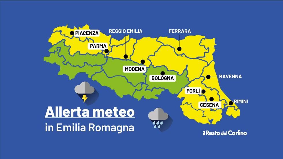
And so almost the entire region is back in check from Monday evening: according to forecasts, only the mountain and hill areas of Emilia will be ‘saved’ (i.e. the hills of Bologna, Modena, Reggio Emilia, Parma and Piacenza). All areas of the plainsinstead they return to risk of cloudbursts. And to think that the Lower Modena area has just declared the full emergency over Secchia river (video) which caused so much damage during the last wave of bad weather a few days ago.
But the storms won’t let go: “Residual rainfall” is expected on Tuesday on the reliefs and Romagna. From the afternoon, clear or slightly cloudy, but with a tendency towards a gradual increase in stratified cloud cover during the night”.
The only good news comes from the front temperaturewhich you do not predict will decrease significantly. If tomorrow the storms arrive a little too late to provide relief (but the minimums are still reported to decrease slightly), on Tuesday the minimums will stabilize around 20 degrees, while the maximum temperatures are dropping: between 26 and 29 degrees. Even the mare will be affected by bad weather and is expected to be slightly rough to locally rough.
Also Wednesday it will be an uncertain day, with “widespread showers, especially in the Emilian areas, which could also take on a stormy character. Gradual increase in the pressure field from Thursday with clear skies or slightly cloudy and maximum temperatures between 27 and 30 degrees”. On Thursday it will be summer again, but the long-term forecasts – according to unreliable definitions – say that it is better not to get used to it.


