The weather is about to undergo a radical transformation. After days of oppressive heat, the weather forecast indicates the arrival of a decidedly cooler phase. Weather models suggest that the intense heat wave that hitItaly is about to end. Yesterday, Saturday, the entry of a cooler and more unstable air mass of Atlantic origin triggered a significant change in several areas of the peninsula.
The weather at Northern Italy from the afternoon it was characterized by scattered thunderstorms, with an initial drop in temperatures. In the Central-Souththe heat was moderate, but with a decrease compared to Friday.
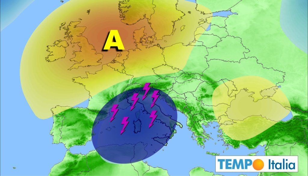
As the week begins, the weather forecast indicates an even more marked change. The arrival of a “cold drop” at altitude on theItaly will be responsible for this weather change. This unstable vortex, loaded with fresh air at high altitude and isolated from the main Atlantic low-pressure circulation, will significantly influence weather conditions, especially in the central-northern regions. In these areas, widespread rain, thunderstorms and a further drop in temperatures are expected.
The weather will undergo a notable freshening, with temperatures likely to drop below seasonal averages between Monday And Tuesday to the Centre-North and Sardinia. This abrupt change in weather could be accompanied by extreme weather phenomena, such as hailstorms. As for the weather Southern Italyand even more so Sicilythe latest updates suggest that it may remain on the edge of this worsening, but trajectory and evolution of the cold drop are still being defined. Therefore, a direct involvement of the southern regions in the weather change cannot be ruled out.
It is important to highlight that weather patterns like this cold drop are often associated with a high degree of forecast uncertainty. Even a few days after the event, these weather patterns are difficult to predict accurately. There is a possibility that yes unexpected storms occur or, on the contrary, that weather conditions remain more stable than expected. This makes weather forecasting a complex and constantly evolving field.
The current weather conditions are the result of a combination of atmospheric factors that include high pressure and the influence of Atlantic currents. The heat wave that is affecting much of the peninsula is due to an area of high pressure that has remained on theEurope southern, preventing the entry of cooler air. However, the arrival of an Atlantic disturbance could break this weather balance, leading to a significant change in weather conditions.
In the context of this weather change, the dynamics of atmospheric dust plays a crucial role. The dust coming from the Sahara can influence cloud formation and, consequently, precipitation. The presence of dust in the atmosphere can favor the formation of condensation nuclei, essential for the formation of raindrops. This phenomenon could amplify the intensity of the storms forecast for next week, further influencing the weather.
Sunday the weather will be characterized by a further increase in instability, with thunderstorms that could also extend to the central regions. Temperatures will begin to drop more sharply, especially at North and in areas affected by storm phenomena. In Northern Italy there could be areas with local heavy rainfall and thunderstorms also responsible for downpours.
Next week’s weather will therefore be characterized by a radical change. The arrival of the cold drop will bring a significant temperature drop, with temperatures possibly dropping by as much as 10-15°C compared to Friday’s values. The weather will be unstable across much of the country, with rain and thunderstorms mainly affecting the Central-North.
This weather change will also have repercussions on sea conditions. Forecasts indicate an increase in wave motion, especially in western seas, with possible storm surges on exposed coasts. The marine weather will therefore have to be kept under control for those planning nautical or beach activities.
The weather in the Alpine and pre-Alpine regions will deserve particular attention. The arrival of cooler air at altitude could lead to snowfall on the highest mountains. This extreme weather phenomenon could occur at altitudes above 2500-3000 meters.
In short, the weather in the next few days will be characterized by a significant changewith the transition from intensely hot conditions to a cooler and more unstable phase.


