A cordial greeting to all readers from the CMS editorial team.
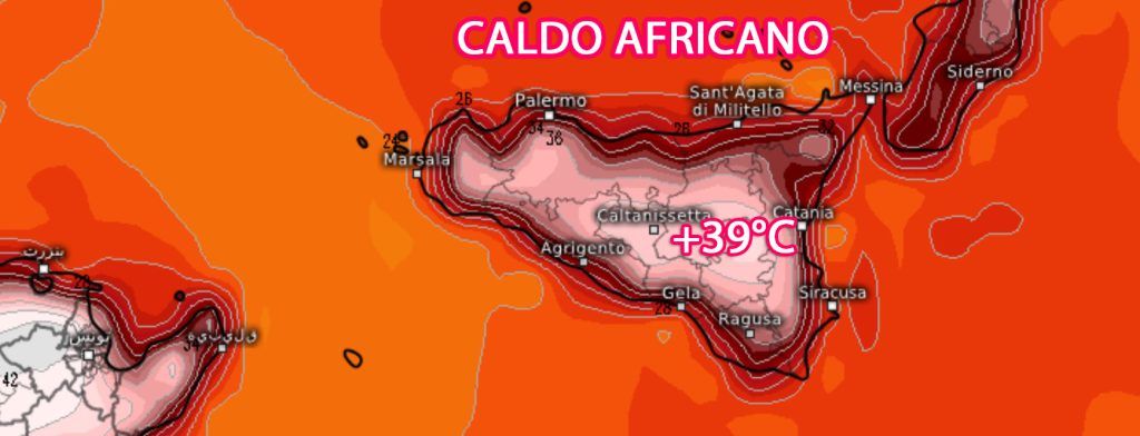
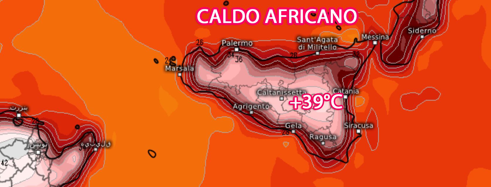
In the central Mediterranean, after the passage of a weak disturbance of North African origin, there will be a gradual improvement in atmospheric conditions, due to an increase in atmospheric pressure which will make use of a sub-tropical contribution at altitude which will be fueled by a Atlantic sagging arriving in the next few days between the Iberian peninsula and the nearby Atlantic. The arrival between Western Europe and North Africa of this trough with a mass of fresh and unstable air will activate a flow of very hot air towards the central Mediterranean coming directly from the Saharan hinterland which, starting from Tuesday, will affect a large part of the central-southern regions, especially Sardinia and partly especially western Sicily, where it will be reached by isotherms around 1500 meters above sea level +24/+25°C.
This will result in a sharp rise in temperatures that will be more felt along inland areas but also along mountainous areas, as they are not reached by sea breezes. The effect also accentuates the heat subsidencei.e. the compression of the various layers of the atmosphere given that in high pressure regimes descending motions are activated, i.e. from top to bottom which inhibit the formation of clouds and at the same time favor further overheating of the air mass.
But now let’s take a detailed look at the weather forecast for the next few days.
Estimated time for Monday 17 June
In the early morning we will initially have cloudy sky conditions along the central eastern areas of the island, with some residual phenomena between the Messina area and the Etna area but improving throughout the day.
Elsewhere the day will see partly cloudy conditions.
Winds which will be weak with variable direction.
Mari calm or not very moved.
Temperatures which will tend to gain a few degrees compared to today.
Estimated weather for Tuesday 18 June
From the morning and throughout the rest of the day we will have clear or slightly cloudy sky conditions everywhere.
Winds weak with variable direction or with a breeze along the coasts.
Mari generally calm or not very moved.
Temperatures further increasing, more sensitive along the internal areas of the island where peaks of 37/+38°C.
Estimated time for Wednesday 19 June
A day that will see clear or slightly cloudy skies everywhere except for some local passing fog.
Winds mainly weak with variable direction or with a breeze along the coasts, except for temporary reinforcements of Scirocco along the western sector of the island.
Mari generally calm or not very rough, while the Strait of Sicily offshore will be temporarily rough.
Temperatures further increasing with peaks close to 40°C over most of the internal areas of the island.
Article by: Antonio Cucchiara
©centrometeosicilia.it
Follow us on: https://www.facebook.com/centrometeosiciliano/
Telegram channel: https://t.me/centrometeosicilia
Post Views: 3


