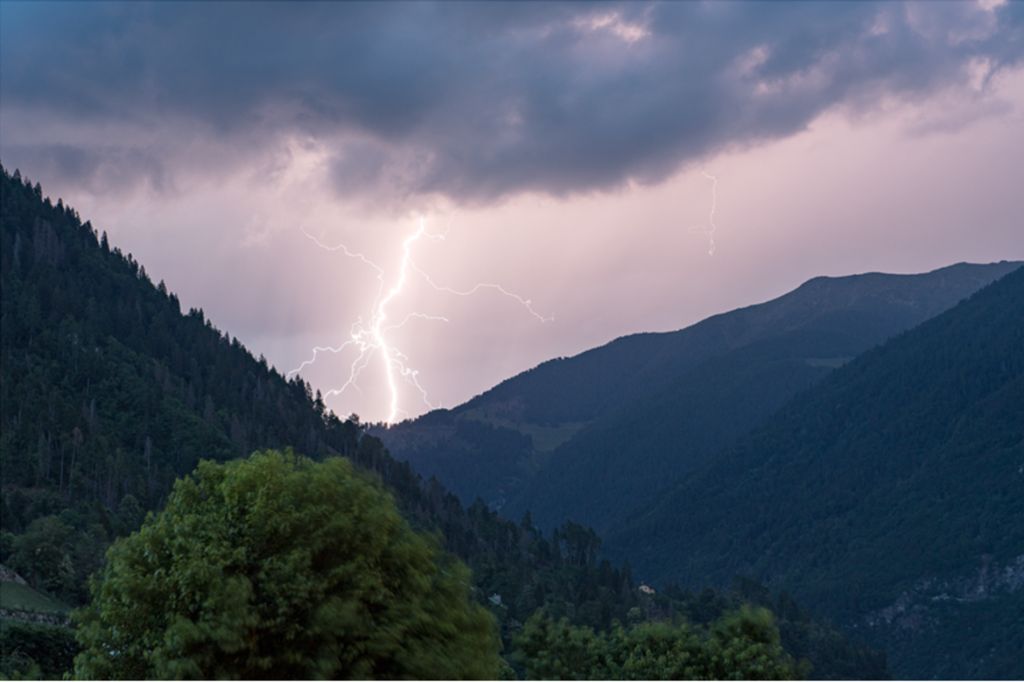
177 interventions throughout the province, for an hour of bad weather, following a storm line that crosses the whole of Trentino, between strong gusts of wind, frequent lightning strikes and local hailstorms. This is the toll of the bad weather that hit the provincial territory yesterday evening.
Precipitation was very irregular, on average between 15 and 30 mm, with values maximums of 52 mm in Daone (Malga Bissina) and 42 mm at Passo Rolle. The most intense gusts were recorded in Torbole (34 m/s or 120 km/h) and in Trento (24 m/s or 85 km/h).
177 calls were received by the single emergency center for collapses, collapses, flooding and falling trees or branches, but no event was particularly serious.
Here are more details.
Today the sky is serene and clear, without the Saharan haze of recent days, and with temperatures slightly dropping. However, conditions are destined to become more unstable in the next few hours with the transit of a second disturbance, which will enter the Mediterranean from France and station over Corsica for the next few days.
A gradual increase in showers and thunderstorms is expected in Trentino this afternoon, but especially in the evening and next night, although less intense than those recorded yesterday.
Tomorrow, Sunday 23rd, will start off disturbed with cloudy skies and precipitation and will undergo a gradual improvement, albeit partial, with clouds alternating with clear spells and some showers possible even in the afternoon. Temperatures will drop in the maximum values and we could have some Föhn gusts in the valley.
In the first days of the week, sunny in the morning with some showers or thunderstorms in the afternoon, especially in the mountains, while more stable conditions and rising temperatures are expected from Wednesday.
The rainfall that affected Trentino in the night between 20 and 21 June caused some of the first peaks to be exceeded attention thresholdsfor example those of the river Sarcaof the stream Walnuts and of theAdige.
From a hydrological point of view, the passage of the rapidly moving storm front from the south-west to the north-east generated rapid responses not only due to the accumulations of precipitation that occurred but also due to the initial conditions of the basins which were saturated for the precipitation in recent weeks and for the flowing base flows which are high both as a result of the precipitation that fell in recent weeks and the melting of the snow.
The Single Emergency Center (CUE) received 177 calls, divided as follows:
51 in Alta Valsugana;
3 in the Cimbrian Highlands;
7 in Alto Garda and Ledro;
12 in the Giudicarie;
1 in the Paganella area;
1 in Primiero;
8 in the Rotaliana;
51 in the Adige Valley;
6 in Val di Fassa;
6 in Val di Fiemme;
1 in Val di Non;
22 in Vallagarina;
1 in Val di Cembra;
2 in Val di Sole;
5 in Valsugana and Tesino.
The Fire Brigade managed the interventions with 5 operators; from the Giudicarie to the Fassa Valley, mainly southern Trentino.
No event of significant severity was recorded and the calls refer to the following types: subsidence/collapses, landslides (6), falling branches or trees (76), flooding (60), disconnections of the road surface (19), other services (12).


