Every second the equivalent of a truckload of plastic ends up in the seas around the world. In a year, over 12 million tons of bottles, bags and objects of all kinds reach the oceans and of which, once offshore, we inevitably lose track. Monitoring their fate would instead be very useful for organizing mitigation and cleaning interventions in the seas, and a new ESA study seems to have found the solution: a strategy that uses supercomputers and cutting-edge research algorithms to identify plastic floating on the sea surface using images taken by satellites.
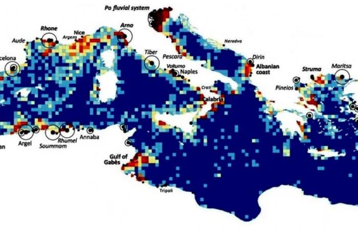
The dirtiest waters in the Mediterranean are Italian
To be visible from space with the satellites currently available, the plastic must aggregate in floating formations, known as windrows, patches, stripes or swaths, which often take the form of long filaments created by the convergence of sea currents, and can reach even dozens of kilometers in length. The presence of a waste strip indicates a high level of pollution in a specific place and time. Thanks to the research, published in Nature Communications and in which the Institute of Marine Sciences of the National Research Council of Lerici also participated, it has been demonstrated that the abundance of these patches is sufficient to draw pollution maps and monitor how the situation over time.
The study used a series of 300,000 satellite images with a spatial resolution of 10 meters, taken every three days for six years by the Sentinel-2 satellites of the Copernicus program. And although the sensors of these satellites are not designed to recognize waste, the analysis of the satellite images, carried out with supercomputers and advanced algorithms, managed to produce the most accurate map ever made of plastic pollution in the Mediterranean Sea. In this way, validating the technique, and allowing several discoveries to be made on the dynamics that dominate the arrival of waste in sea waters. For example, demonstrating that the accumulations in coastal windrows are mainly due to the emissions of terrestrial waste in the days immediately preceding.
“Looking for debris aggregates several meters high on the sea surface is like looking for needles in a haystack,” explains Stefano Aliani, research director and oceanographer at Cnr-Ismar. “Despite non-specialized satellites, we were able to identify the most polluted areas and their main changes over weeks or years. For example, we observed that a lot of debris enters the sea during storms.”
Among the possibilities offered by this new monitoring technique is also that of verifying the effectiveness of the strategies implemented to limit marine pollution. The city of Rome was chosen to test its effectiveness, where since 2019 special waste-catching barriers have been installed that serve to reduce the amount of plastic transported into the sea by the Tiber. Using satellites, the study confirmed their effectiveness, calculating that since the barriers came into operation, the waste found in the waters near the city has dropped by 38%.
“This instrument is ready to be used in different contexts: we are convinced that it will teach us a lot about the phenomenon of waste, including the identification of sources and pathways to the ocean” says Giuseppe Suaria, researcher at Cnr-Ismar in Lerici. “Furthermore, our detection capacity would improve enormously if we put into orbit an observation technology dedicated to plastic. The implementation of a high-resolution sensor specifically dedicated to the detection and identification of floating objects of one meter in size could also be useful in other relevant issues such as monitoring oil spills, cargo losses from ships or search and rescue activities at sea”.


