


Already at the end of the week, the approach towards Italy of the trough in action over Spain, the same one responsible for pushing the anticyclonic promontory towards Italy, risks causing violent thunderstorms and hailstorms.
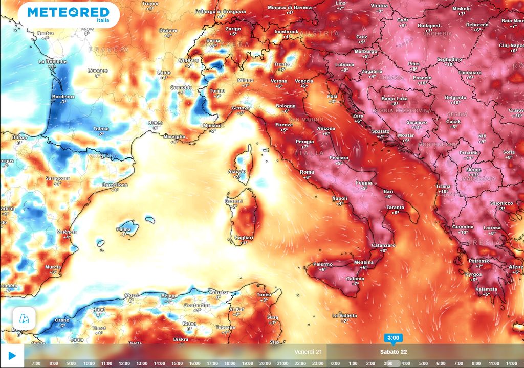
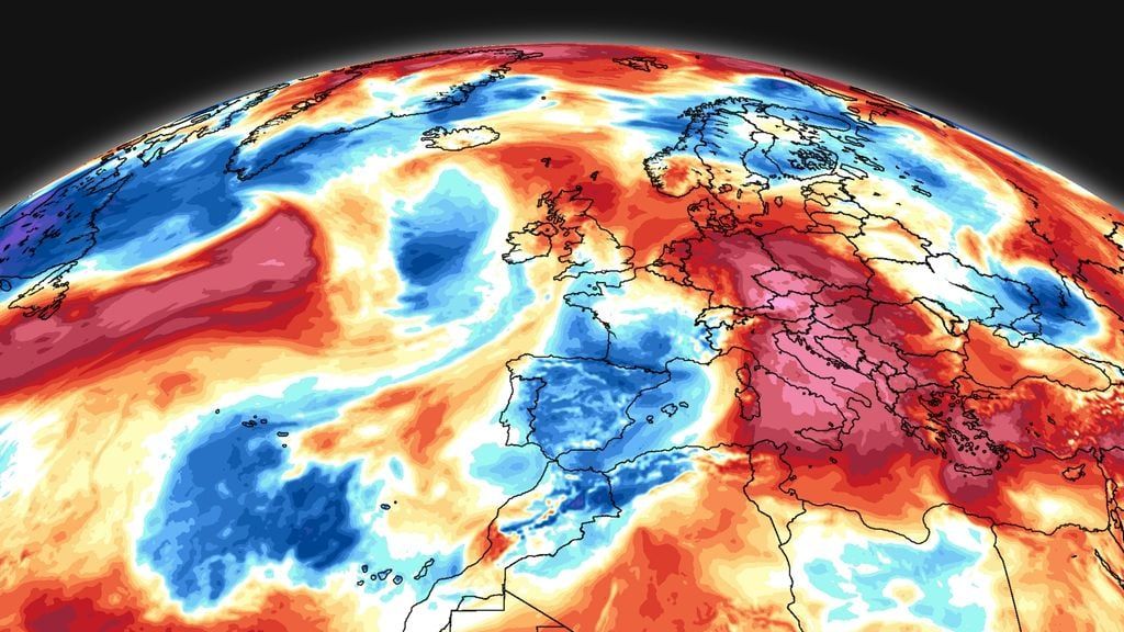
As widely expected, a subtropical anticyclonic promontory, belonging to the torrid Saharan anticyclone, is affecting our country, bringing the first real heat wave of the season to almost the entire national territory.
Even in the next few days the maximum temperatures, already quite high, will continue to rise, as we have seen in this one item. Yet the hot air, of continental subtropical origin, flowing over the waters of the Mediterranean will tend to cool in the lower layers, favoring the accumulation, near the ground, of a cushion of warm and humid air.
The accumulation of these very warm and humid air masses in the lower layers will represent a good fuel, made available to the atmosphere, as soon as the first Atlantic front manages to erode the anticyclonic promontory.
In fact, already at the end of the week, the approach towards Italy of the trough in action on Spain, the same one responsible for the push of the anticyclonic promontory towards Italy, risks causing strong thunderstorms.
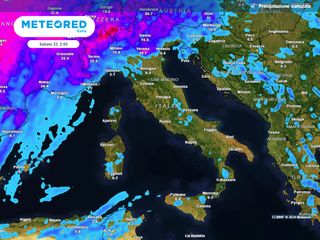
The first strong storms in the pre-Alpine area on Thursday
The intense heat of these days seems destined to end with a bang. Already during the day of Thursday 20 June the North African anticyclonic promontory will begin to be eroded in the North-West by the approach of the ascending branch of the Spanish trough, which will cause a drop in geopotentials at altitude, with the consequent entry of cooler air at altitude, ready to destabilize the entire tropospheric column .
This, also added to the enormous values of Cape (Convective Available Potential Energy) present in the lower layers, will facilitate the development of intense convective motions, with the formation of the first intense thunderstorms in the pre-Alpine area, between western Piedmont, upper Lombardy, with the possibility of evening trespassing up to the plains.
While on Friday the main trough axis, still over France, will undergo a process of “stretching”, with the isolation of a “tear/off” near the Gulf of Genoa which will cause a first wave of generalized bad weather across part of the North, from Piedmont to Lombardy and Trentino.
Some of these storms could be very intense, causing local downpours, accompanied by strong gusts of wind and medium-sized hail. By the evening the storms will move towards Veneto and Friuli, affecting the foothill areas, up to the plains.
Over the weekend there is a risk of extreme weather events in the North
But the storms on Thursday and Friday will be a sort of appetizer of what could happen in the northern regions, and beyond, over the next weekend. From the numerical simulations it emerges that over the weekend the main trough, followed by colder air in the middle troposphere, will shift its axis to Northern Italy.
Furthermore, the advection of positive vorticity at altitude will facilitate the isolation of a “cut/off”, that is, a real one cold drop at altitude which could affect the weather over much of Italy even during the week after next weekend.
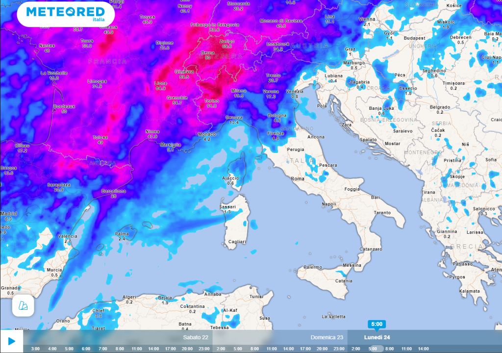
Saturday and Sunday strong bad weather
In the meantime already Saturday 22 the isolation of this cold drop will produce conditions of strong atmospheric instability throughout the North, with showers and thunderstorms, locally also of strong intensity.
Given the enormous amount of potential energy available the risk of witnessing the formation of rather impressive mesoscale storm systems, and probable supercells, capable of giving rise to storms and important hail events, will be high in many areas of the North.
By Sunday, part of the bad weather will also affect the central regions, in particular the Tyrrhenian coasts, where showers and thunderstorms will arrive, locally also of strong intensity. It is yet to be clarified whether some bad weather will reach the south and Sicily by Monday.

