


reading time
2 minutes, 8 seconds
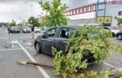
There marked instability which lasted until the evening hours of Friday and further weakened during the night. The bad weather in fact followed the low pressure vortex that moved between Germany and Poland. But the pressure on Italy does not increase significantly because there are still some infiltrations of fresh air which, sliding over the Alps, manage to reach France where there is a small secondary minimum. This fresh drop will not have a great impact on our country during the current day but on Sunday it will and therefore we expect new storms of a widespread nature. So let’s look at the forecast:
WEATHER SATURDAY 1 JUNE: North, quite sunny in the morning except for thickening in the eastern Alps with some isolated rain. In the afternoon, development of thunderstorms in the Alpine and pre-Alpine sectors as well as in the Emilian Apennines with some local overshoots up to the adjacent plain sectors. Sunnier on the central and eastern plains. Center: overall sunny except for isolated afternoon thunderstorms developing between Tuscany, Umbria and Marche, even more isolated between Lazio and Abruzzo. South, cloudy between Campania, Puglia and Basilicata with some isolated rain in the morning. In the afternoon some fleeting thunderstorms over the Campania-Lucania Apennines, locally spreading to Puglia. Temperatures slightly increasing in the North, stationary elsewhere. Winds southerners between weak and moderate. Rough seas.
WEATHER FOR SUNDAY 2 JUNE: North, scattered and cleared clouds in the morning with greater accumulations in the Alpine areas and Liguria associated with some showers. Afternoon with the development of more widespread thunderstorms between lower Piedmont, the Ligurian hinterland, the Emilian ridge with phenomena that will quickly rise towards the lowland areas especially between Lombardy, Triveneto and Emilia Romagna. It improves between evening and night except for some showers or thunderstorms between upper Piedmont and upper Lombardy. Center: scattered and cleared clouds in the morning with low probability of phenomena. Afternoon with development of even intense thunderstorms between Tuscany, Umbria and Marche, locally spreading up to the Adriatic coast. More isolated phenomena but also possible between Lazio and Abruzzo. South, showers and local thunderstorms transiting between Campania, Basilicata and Puglia, attenuating from the west during the afternoon. Scattered and cleared clouds elsewhere with some afternoon thunderstorms in central-eastern Sardinia. Temperatures slightly decreasing in the North and South. Winds weak or moderate at variable speed. Slightly rough seas.
Do you want to know if there will be wind in your area? We also have national and regional wind maps available. Click here for details >> Twenty.
Curiosity: in case of rain, is hot or cold air better for breaking glass? Here is the answer >> Here.
Follow us on Google News


