


The long phase of bad weather in the northern regions is not over, for which strong thunderstorms are still forecast. The weather in the Center is better, although not entirely stable. Warm and sunny in the South. Updated weather forecast
Strong bad weather has been characterizing the weather in Northern Italy for several weeks now, while a first wave of African heat over the weekend has already caused at the beginning of June the 37/38°C between Sicily, Sardinia and Puglia.
The North African anticyclone is now retreatingleaving room for cooler western currents, and no longer providing desert sand.
Are we expecting several heat waves between July and August? Here is the latest trend line of the Meteored model
It is said that the flow, over the Mediterranean, is becoming more zonal, that is, more oriented in the west-east direction than in the north-south direction, which is a good thing because it prevents temperatures from reaching too high values, but it is not yet capable of restoring atmospheric stability on the peninsula.
A vast depression area located between the United Kingdom and the Scandinavian Peninsula in fact, it will continue to influence the weather conditions of our countryand now let’s see together how.
Forecast for the start of the new week: more bad weather in the North
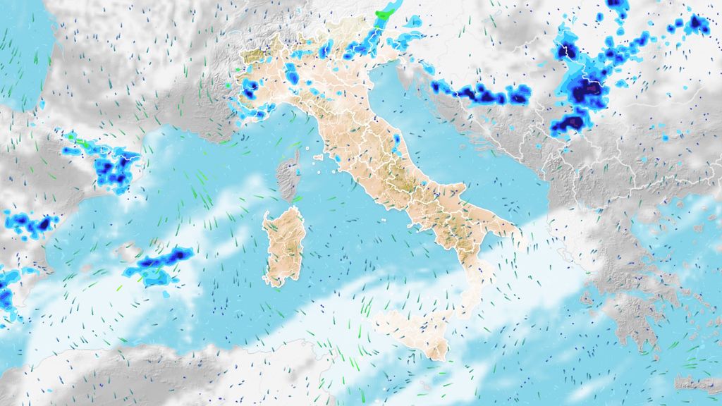
Today Monday 10th the weather improves in the Centre-South, with prevailing sunshine.
However, the atmosphere in the Centre-North remains unstable, and some showers or brief thunderstorms are already underway between Tuscany, Umbria, Marche and upper Lazio. More widespread and strong instead in the north, with associated possible strong gusts of wind and hailstorms, specifically between Triveneto and eastern Lombardy.
For eastern Lombardy, the alert issued by the Civil Protection Department still applies, orange for thunderstorms, the highest on the scale for thunderstorm risks. A yellow alert applies for the Triveneto and Tuscany.
Similar situation tomorrow, again rain, showers and thunderstorms in the centre-northwhile there will be prevailing sunshine in the Centre-South.
We therefore expect more clouds but occasional showers between Sardinia, Umbria and Tuscany. Precipitation becomes more likely over Liguria, Marche and Piedmont more intense once again are expected between Lombardy and Triveneto.
Next week’s weather, where will it rain in Italy? Meteored’s precipitation forecast
The winds remain locally sustained from the south-southwest over Sardinia, Liguria and the central Tyrrhenian coasts, the ridges of the central-southern Apennines, the Ionian coasts of Puglia and Calabria.
The seas around Sardinia, the Ligurian Sea and the central-northern Tyrrhenian Sea are very rough.
This scenario will tend to repeat itself on Wednesday too, with highly unstable atmosphere in the North and the continuous alternation of showers and thunderstorms with drier moments and perhaps some clear spells; occasional disturbances over the central regions and increasingly stable and sunny conditions as we move southwards.
And the temperatures?
A configuration that also has repercussions on temperatures. They are on average decreasingmore sensitive to the south after this weekend’s high peaks, and will be cooler for northern regions.
In the north, maximum temperatures are expected between 22 and 26°C, in the center locally still up to 30°C, and in the south they will reach between 30 and 34°C, where the southern ends of Sicily and Calabria will still be touched from the subtropical heat bubble.
Trend for the weekend: still divided between thunderstorms and summer heat
For the second part of the week, from the point of view of the state of the sky, there are no particular changes in sight: the low pressure area over central Europe tends to be rather stationary, and consequently the weather over Italy will also change little .
Over the weekend, a new passage of rain and thunderstorms is probable in the north, with more stable and sunny weather in the centre-south, with fully summer temperatures
In the North and Northern Apennines there will still be bad weather on Thursday, on Friday it seems there will be a short drier break, although often cloudy, but again between Saturday And Sunday a new passage of rain and thunderstorms seems likely for the same regions.
This is why during thunderstorms the sky turns green
In the centre, moments of clearer skies will alternate with others in which it will be more veiled, but essentially in a dry context; finally, in the south, sun and fully summer temperatures will prevail.


