

reading time
2 minutes, 10 seconds
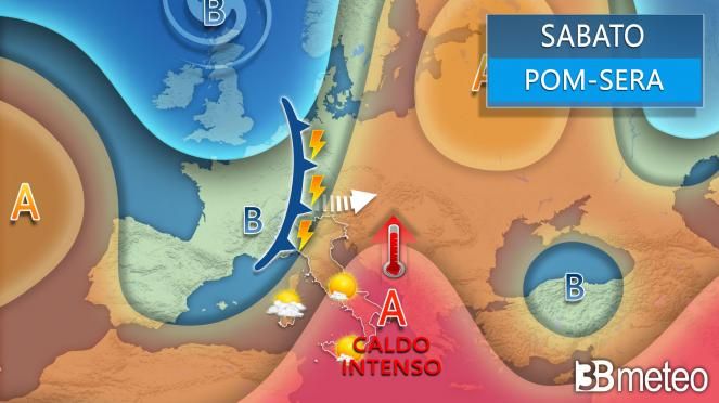
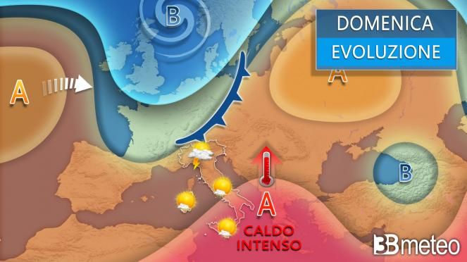
After one very short anticyclonic pause which will grant a stable and sunny Friday to almost all of Italy, the weather will get worse again North. No vortex this time but an intense disturbance Atlantic resulting from the contact between the cooler oceanic currents and the very warm air of North African origin rising towards the Mediterranean. The front will pass between the second part of Saturday and Sunday night bringing heavy thunderstormseven in the nature of a storm and accompanied by hailstorms of large dimensions. Then it will be followed by a aftermath of instability which, however, should not lead to particularly significant phenomena during Sunday. While the North will deal with yet another bout of bad weather, the Center and the South will be affected by one hot air bubble of Saharan origin which will bring, especially on Sunday, considerable maximum temperatures, particularly in the far South. Here then is what is expected for these two days.
SATURDAY WEATHER: North, initial sunny weather conditions with some first thunderstorms in the western Alps. From the afternoon it worsens in Valle d’Aosta and Piedmont with strong thunderstorms extending between the evening and night also in Lombardy, Trentino Alto Adige and Veneto. Risk of large hail. Liguria, Emilia Romagna and Friuli are out of the worsening. Centersunny day even with veils and layers arriving in the afternoon over the Tyrrhenian regions, sky at times whitish due to the Saharan dust. Southveils and layers in Sardinia, sunshine prevailing elsewhere but with a whitish sky due to the Saharan dust. Temperatures slightly decreasing in the Northwest, further increasing elsewhere. Winds rotating from the southern quadrants over the western and northern basins, residual mistral in the South. Mari the western and northern basins are choppy, the others are slightly choppy or locally choppy.
SUNDAY WEATHER: North, at times unstable in the Alps and Pre-Alps with the possibility of short showers and isolated thunderstorms, more likely in the afternoon hours. Irregular clouds in Liguria and on medium-high plains with only sporadic phenomena. More sun on low plains and eastern coasts. Centersome cloudy disturbances in the Tyrrhenian regions, especially in Tuscany where some isolated rain cannot be ruled out in the northern sectors, sunny elsewhere. South sunny with some harmless haze. Temperatures slightly decreasing in the North and in part of the Centre, further increasing in the South with intense heat. Winds weak or moderate southern ones. Mari moved.
Do you want to know if and when it will rain in your area? Discover the section dedicated to rainfall maps >> Here.
When it rains there are some extra precautions to take when driving, such as checking the correct tire pressure. >> Here.


