
The African Anticyclone Minos will become even stronger in Italy in the next few days, thus worsening the heat wave that is already affecting a large part of our country. Subsequently, however, thunderstorms will return to some regions.
Meanwhile, Wednesday 19 June thermometers will go beyond the threshold of 35/36°C on Lazio, Campania, Basilicata, Puglia And Calabriabut we will have even higher peaks in the internal areas of the Sicily and of Sardinia.
On the warm front there will be no breaks even on the days of Thursday 20th and Friday 21st June. Indeed, the maximums will rise further until they reach peaks close to 40°C on many internal areas of the Center and the South. You can even touch peaks of 41-42°C in Puglia, Basilicata, Calabria, Sicily and up to 43°C in Campania. Only the coasts and mountain areas will have slightly more bearable temperatures, but still higher than the averages for the period.
The good weather, combined with very sultry heat, will also be of interest much of the Northwith greater suffering on the areas of Po Valley.
Such extreme and prolonged heat can pose a serious health hazard, especially for the most vulnerable people such as the elderly, children and people with respiratory or cardiovascular diseases. It is recommended to drink a lot, avoid the hottest hours of the day and stay in cool, air-conditioned places as much as possible.
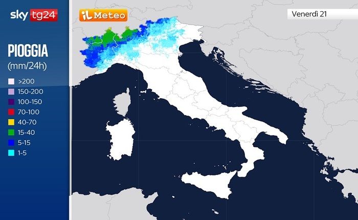
Despite this context of full summer heat, at times exceptional for the period, the first signs of fatigue of the anticyclone will be noticed Minos from Thursday 20 Junewhen thunderstorms will begin to develop more frequently close to the alpine and pre-alpine mountains of the Northwest. Also Friday 21 June the same areas will suffer the effects of greater instability, with increasingly frequent storm phenomena which towards the evening will also move to the neighboring flat areas, and then travel towards the Triveneto.
Slowly, from weekend. With the arrival of a core of fresh air of Northern European origin, with some thunderstorms and the ‘deflation’ of high pressure, we will witness the probable defeat of Minos: frequent showers are expected, especially from Sunday onwards and for much of the next week with a gradual drop in temperatures. The last week of June will be eventful with prevailing sun in the morning and strong thunderstorms in the afternoon; in practice we will experience a somewhat equatorial climate after the North African heat and the Saharan dust of Minos. An Italy, increasingly, towards a general tropicalization of the climate.


