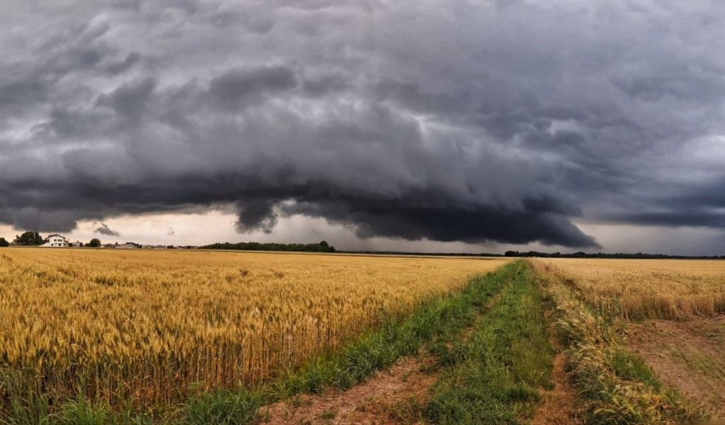
A yellow weather alert has been issued for the risk of showers and thunderstorms, also in the province of Pavia, starting from 2pm today: the most acute phase of the disturbed passage will be between the afternoon and early evening.
Weather alert for risk of thunderstorms
For the remaining part of today, Monday 1 July 2024, they are expected rainfall in the form of showers and thunderstorms. The most acute phase of the disturbed passage is expected to coincide with the afternoon and early evening.
Precipitation is expected to move from North-West to South-East and are expected to run out by the early hours of Tuesday 2 July 2024. Discontinuous phenomena are expected in the western sectors and Valcamonica, locally even of moderate intensity, with cumulative precipitation peaks of up to 30-50 mm, while in the Prealps and central plain -Eastern storm phenomena may take on more organized and structured characterpotentially also forming storm lines with peak cumulatives that can reach 50-80 mm e probable hail. Reinforced ventilation is expected on the plain and in the central-eastern Prealps, with values up to 50-60 km/h between afternoon and evening, with further temporary intensification during thunderstorms.
They are expected for tomorrow, Tuesday 2 July 2024 conditions of instability, which may become more pronounced from the afternoon in the pre-Alpine area, where the activation of scattered showers and thunderstorms of mainly weak intensity cannot be ruled out. It will be possible for precipitation to decrease in the evening, with possible intensification, towards the high plain areas.
The weather forecast
Until midnight Monday 1 July 2024 – Partly cloudy until early morning, then cloudy or at times very cloudy. In the late morning local showers or thunderstorms on the Alps and Prealps, in the afternoon extending and spreading with more persistent phenomena on the central and eastern lowlands. To the west phenomena attenuating or dying out in the evening. Maximum temperatures in the plains between 27 and 30 °C.
Tuesday, July 2, 2024 – Clear or slightly cloudy in the morning with some clouds and some thickening, progressively increasing coverage between the afternoon and evening, especially in the northern hills and high plain areas. From the afternoon, occasional weak rainfall on the Alpine and pre-Alpine mountains, intensifying in the evening, especially on the pre-Alpine belt, and probably extending to the high plain areas. Stationary minimum and maximum temperatures. In the plains minimums between 18 and 21 °C, maximums between 27 and 30 °C.
Wednesday 3 July 2024 – Variable, between cloudy and very cloudy, in the late evening irregularly attenuating, especially in the west. In the morning scattered to widespread precipitation in the pre-Alpine areas, scattered to occasional in the Alpine and plain areas; in the afternoon scattered showers mainly on the mountains, in the evening phenomena generally attenuating with some residual phenomena in the east. Minimum and maximum temperatures decreasing, especially in the maximum values. In the plains minimums around 18 °C, maximums around 24 °C.
Thursday 4 July 2024 – Partly cloudy with some thickening in the morning and irregular cumulus clouds in the afternoon over the reliefs. Probable local showers in the northern mountains, occasionally extending to the central-eastern high plains. Minimum and maximum temperatures increasing, especially in the maximum values.
Friday 5th and Saturday 6th July 2024 – Friday partly cloudy to cloudy, with more consistent accumulation on the mountains where some local showers are not excluded. Temperatures rising. Saturday irregularly cloudy in the plains, generally cloudy in the mountains with possible scattered showers in transit from west to east, phenomena less probable on the plains. Temperatures without significant variations.
