

reading time
2 minutes, 33 seconds
UPDATE SUNDAY AFTERNOON. During the afternoon, new showers and thunderstorms formed in Friuli VG and are affecting Udinese and Pordenone more directly, up to and including the Julian Prealps. The cloud body that is crossing the Mediterranean is giving rise to some insignificant rainfall between the major islands and lower Calabria.
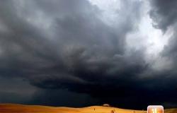
SITUATION SUNDAY MORNING. Between the evening and the night just gone by, an unstable pulse passed through part of the northern regions, distributing showers and thunderstorms, some of which were of strong intensity. Lombardy and Triveneto were hit with locally violent phenomena which caused quite a bit of damage. In the province of Varese the most critical situations occurred between Gallarate and Malpensa, where the storm accompanied by violent gusts of wind caused the collapse of several trees and damaged some homes. The Fire Brigade had to carry out several interventions on Saturday evening in the Varese area also due to the flooding which created many difficulties for motorists, some of whom remained stuck in the underpasses. The storms did not spare the province of Como and the Bergamasco area, where there were hailstorms and flooding.
Varese:
Malpensa:
San Paolo d’Argon (BG):
In Veneto strong storms hit Bellunese and Trevigiano with rainfall accumulations that quickly exceeded 40mm in the foothills. Even strong storms did not spare the Venetian and Friulian coasts, with the phenomena ending during the night.
MEDITERRANEAN FRONT TOWARDS SARDINIA AND SOUTHERN ITALY. Meanwhile, another pulse of instability is approaching from the Mediterranean latitudes to Italy, targeting the major islands and the lower Tyrrhenian Sea. However, it is a disturbance that will have much more limited consequences than the episodes of bad weather that occurred in the North and which will involve Sardinia, Sicily and locally Campania with some light rain during the day. Here is the forecast for the next few hours in detail.
SUNDAY WEATHER. To the North initial clusters over Liguria, the upper Po Valley and the central-eastern Alps but with a tendency for increasingly large clearings extending from the North-West, with mostly sunny weather during the day. An exception will be some accumulations on the Venetian and Friulian mountains, with isolated showers in the afternoon-evening. To the Center sunny or partly cloudy with some additional cloudiness in Tuscany in the morning. In the afternoon other clusters forming along the Apennines, especially in the Umbria-Marche sector, with short showers easing by the late evening. To the South Increasing clouds over Sicily and Calabria with some rain arriving during the day on the central-eastern sectors of the island, up to Reggino in the late evening. Clouds also increasing in Campania between the afternoon and evening with the possibility of local showers in Cilento towards the end of the day. Elsewhere sunnier weather. In Sardinia some rain in the central-southern areas, easing in the evening. For all the details enter the section Italy weather.
Do you want to know if and when it will rain in your area? Discover the section dedicated to rainfall maps >> Here.
In the event of severe bad weather or storms with the risk of flooding/flash floods, there are certain actions to follow to avoid serious dangers, including not underestimating the force of the water on the road during a flood. To know more. >> Here.
Follow 3BMeteo on Facebook


