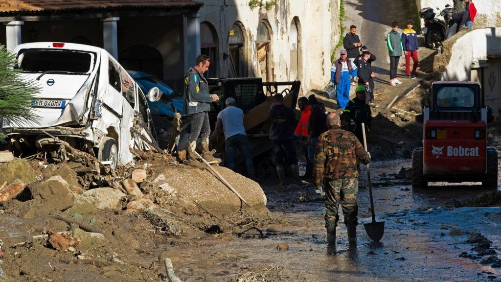
A beautiful territory, certainly, but fragile. Hydrogeological risk in Italy is nothing new, but the numbers give an idea of the size of the problem. There are more than 2 million and 115 thousand buildings which, together with 727 thousand businesses, are located in the areas most exposed to hydrogeological risk. Of the latter, over 84 thousand fall in areas with high and very high landslide danger, with 220 thousand workers exposed to risk. Over 1 million and 300 thousand inhabitants and almost 548 thousand families live in areas at risk of landslides; nearly 7 million people in flood-prone areas.
These are the data from Ispra, which to make them usable is launching a new tool with considerable possibilities. You can easily check if the area where you live or work is in one of the risk areas. Just access the IdroGEO platform and enter your address or geolocate yourself to find out if your business or home is in a risk area. It’s all simple and intuitive, you can also enter data on new events in real time, from your mobile device, on site, and download the information requested in PDF format.
IdroGEO is the national platform on hydrogeological instability created by ISPRA with the aim of providing data and services increasingly closer to citizens, companies, institutions and financial operators. It is aimed at central and local public administrations, decision makers, district basin authorities, entities that manage infrastructure networks, universities and research bodies, businesses and insurance companies, professionals working in the defense sector soil and citizens. The platform is updated and inserts new functions within the Geosciences IR research infrastructure coordinated by ISPRA and financed by the Pnrr MUR.
Not just homes and businesses. IdroGEO contains data and information on the danger associated with landslides and floods in the entire Italian territory: according to the latest official ISPRA data, on a national surface area of 302,068 km2, 18.4% is mapped in the classes with the greatest danger for landslides and floods (55,609 km2). Of the over 213 thousand architectural, monumental and archaeological assets present in Italy, those potentially subject to landslides in highly dangerous areas are over 12 thousand; they reach a total of 38,000 units if we also consider those located in less dangerous areas.
IdroGEO is an application multilingual, multi-device, open source and open data web for the management, consultation, sharing and downloading of data from the Inventory of Landslide Phenomena in Italy (IFFI), the national hazard mosaics for landslides and floods and the indicators of risk. It is a support for risk mitigation policies, territorial planning, programming of soil protection interventions and preliminary design of infrastructure networks. By accessing the platform you enter an ecosystem of data and functions. One of these allows you to define a point of interest on the map and check your exposure to risk. Information that is taking on an increasingly important role also in the field of sustainable finance and for the assessment of financial risks – credit, market, operational – linked to the economic impact due to extreme events that are multiplying as a result of the climate crisis. Information of great interest for the insurance world, especially after the introduction of mandatory insurance for companies against risks arising from catastrophic events and in light of the intensification of hydrogeological risk due to climate risk.
“Italy is the first country with Greece for exposure to seismic risks and the second after Germany for exposure to flood and landslide risks, but it is also the least protected country for these two risks. At the end of 2022, 98% of claims from seismic events and 97% of flood risks in Italy were uninsured”, Martina Bignami, head of the Regulatory and Supervisory Policies Service of IVASS, the Insurance Supervisory Institute, points out during the presentation of IdroGEO. “The premium collection for climate risk dangers – a volume of 5.8 billion, 58% linked to hail – is equal to 5.8% of the total damage business of the sector, for seismic risk – 0.3 billion – it is equal to about 1% of the damage business of the sector, crumbs compared to the collection of the RC Auto sector”.
And gap particularly felt among small and medium-sized companies, while the larger ones usually have adequate coverage. However, “the costs for claims from climate damage have increased significantly: +25% in 2021 and +17% in 2022. For 2023, the data on claims will be much higher in consideration of the catastrophic events that have hit Italy”. Meanwhile, “out of 35 million private homes, less than 2 million homes are insured for catastrophic events, 5.3%, while out of 4.5 million companies, mostly small and micro, the overall protection reaches 7%: medium and large are better, values almost zero for small ones”, reports Sergio Mattiuz, CEO of ANIA Safe, a service company of the National Association of Insurance Companies.
In the meantime, however, “the trend in the last year of the index that measures the costs of premiums collected by branch, the loss ratio, which concerns guarantees for natural disasters, in 2023 reports a surge to 214%, which means that for every 100 euros collected, 214 are spent on compensation paid or set aside. It is a significant deterioration in the technical rate of the class and could lead to cost effects, given that the cost of reinsurance has risen enormously.”
In this context, “insurance and reinsurance companies expect an increase in demand for coverage until 2026, with a related increase in rates, in consideration of the worsening impacts of extreme weather events”. Greater and more rapid awareness of the actual risk on the territory is therefore useful, indeed precious, and IdroGEO takes on a significant role, especially in light of the introduction of mandatory insurance for companies.
IdroGEO is designed to provide clear and complete information, to be easily usable and accessible with different types of devices (smartphones, tablets, laptops, desktop PCs), in order to make the services provided to citizens and businesses more efficient and timely. From May 2020 to today it has been used by over 179,000 unique users with over 390,000 sessions and 9 million views. The technology used for navigation was 63.1% via desktop, 35.3% via smartphone and 1.6% via tablet.
The platform is structured in two sections. In the section relating to the Inventory of Landslide Phenomena in Italy – IFFI, it is possible to consult the data relating to landslides registered in Italy and view the multimedia archive of associated photos and videos. IdroGEO allows the reporting of new landslide phenomena in the area by public administrations (such as municipal technical offices, Forestry Services) and professionals, and the remote management and updating of Inventory data by officials of the technical structures regional IFFI, also with the possibility of acquiring and archiving information during inspections using devices mobile. Being on site, in the place where the landslide was identified, just a few clicks are enough to send information and photos to the platform, which is then updated in almost real time, ‘almost’ because the additions must first be validated.
In the Hazard and risk section, it is possible to view the levels of danger for landslides and floods on a map or extract data relating to the resident population, families, buildings, businesses and cultural assets at risk aggregated on a national, regional, provincial or municipal basis. The user can search for an address, geolocate themselves, query the data and share them on social media, create a report, verify the danger in a point of interest or calculate a scenario with elements exposed to landslides and floods on a polygon drawn on the map.
“We launched the IdroGEO platform 4 years ago in full swing lockdown, a challenge in that difficult moment, and today we can say that it represents a best practice of collaboration between public administrations in the field of communication, dissemination and systematization of information on hydrogeological instability in Italy”, says Ispra president, Stefano Laporta “We are convinced that, to achieve greater awareness among citizens, we cannot ignore the dissemination and promotion of knowledge on such an important topic”.
“Talking about hydrogeological instability also means talking about climate change. The climate crisis represents the greatest challenge that our country will have to face in the coming years due to the impact it will have on the territory and the environment but also on economic activities and people’s lives”, adds the general director of ISPRA, Maria Siclari. “There is a close correlation between climate changes and the severity and persistence of extreme events: in recent years we have recorded an increase in terms of magnitude and frequency of extreme hydrometeorological events. A recent Censis study reports that in Italy the economic losses caused by extreme events and natural disasters amount to 210 billion euros and climate change has caused damage amounting to 111 billion. One in four small and medium-sized businesses has both the possibility of suffering significant damage and a 4.8% greater probability of failing because it is located in areas that we classify as at risk of landslides and floods. The care of the territory must no longer be considered as a cost, but as an investment opportunity. To take this step and adopt the best decisions, knowledge is crucial and we, with IdroGEO, have made it accessible to everyone”.


