WEDGE NEWS – A depression circulation, with a minimum between north-western Italy and south-eastern France, is affecting Piedmont causing widespread rainfall in the region, moderate in the central-southern sector, with snow levels localized at hilly altitudes.
From Sunday evening, with the rapid decrease in temperatures, snowfall began to reach increasingly lower altitudes. In the northern sectors the snow reached 1200-1300 metres, moving on to 800-1000 meters in the western sectors where in the morning it dropped further, until a few flakes appeared on the 500-600 meters of the Turin hill. In the southern sectors, however, since yesterday evening the snow level was lower and starting from 700-900 meters it dropped in the morning to 400-500 meters on the high plain between Cuneo and Monregalese.
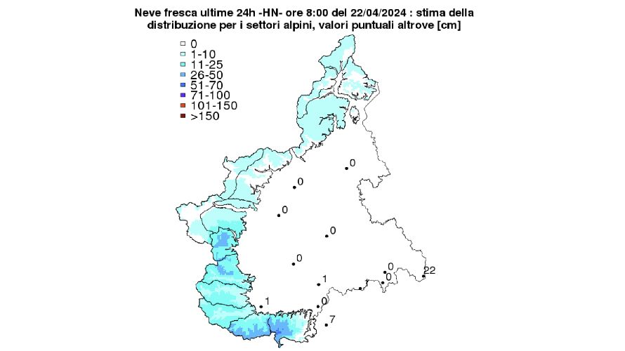
Overall this morning at 8, the stations of the Piedmont snow measurement network recorded at around 2000 m: 5 cm in the northern sectors; 5-10 cm on the Graian Alps and up to the Susa and Chisone Valleys; 25-30 cm between the Germanasca and Po Valleys; 15-30 cm between the Varaita Valley and the upper Stura Valley; 20-35 cm between the Gesso and Tanaro Valleys, with peaks of 40 cm in Limone Pancani (Vermenagna Valley) and 50 cm at Rifugio Mondovì (Ellero Valley).
The meteorological situation will remain substantially unchanged also in the second part of the day and until dawn on Tuesday, with widespread rainfall in the Piedmont area, more intense in lower Piedmont, where it will be moderate or locally heavy. The snowfall altitude will always be located on hilly levels (approximately 700-800 metres), with the exception of Cuneese, Astigiano and Alessandrino, where it will be around 400-500 metres, with possible flakes at lower altitudes.
From Tuesday morning the depression core will move towards central Italy, allowing an improvement in the weather in Piedmont, with a gradual attenuation of instability and weaker, scattered and intermittent precipitation phenomena. The snow level will also gradually increase towards 1000 m. In the night between Tuesday and Wednesday the clear sky will allow the formation of late frosts in the flat areas.
With snowfalls still expected, the danger level will increase up to 3 – Marked from the Monregalesi Valleys to the Pellice and Germanasca Valleys due to the new quantities of snow which could give rise to natural avalanches of medium and, in individual cases, large ones dimensions. In these sectors, detachment caused by low overloading on steep slopes at high altitude will also be possible due to the formation of new wind slabs.
Given the snowfalls, still forecast for today at hilly altitudes, the Arpa Piemonte Functional Center maintains the yellow alert for snow in southern Piedmont for today due to possible falling branches, interruption of services and disruption to traffic.


