Of
Cronache editorial team and Gloria Bertasi
Gusts in the North East up to 109 km/h. Several storms are affecting much of the North but also other regions such as Molise. Maximum attention on the plains in the provinces of Bologna, Ferrara and Ravenna. Possible arctic waves arriving after Christmas due to a destabilization of the polar vortex
This year’s Christmas Eve is full of bad weather, with a scenario that could pave the way for even colder developments in the coming days due to a possible destabilization of the polar vortex. Bora and rain flying are crossing much of Italy as a result of an Atlantic disturbance. Particularly affected are the Centre-North, Campania and Sardinia, with widespread snow below 1000 meters on the northern mountains up to altitudes of 500-700 metres. The situation could worsen further starting from Emilia-Romagna, where the orange alert dominates today and tomorrow some areas will pass to the red one. For this reason the Head of the Civil Protection Department, Fabio Cicilianopresided today at 4 pm, in the headquarters in via Vitorchiano in Rome, at the Department of Protection Crisis Unit meeting civil summoned to make the point – together with the operational structures and the Regions involved – on the evolution of the bad weather, on the current critical issues and on the prevention actions adopted by the territorial civil protection structures.
Damage due to strong gusts in the North East
In Trieste, strong Bora gusts reached 109 km/h and are expected to reach 120 km/h in the afternoon. The strong wind has already caused the first damage. During the morning, reports of fences torn down in the municipality of Triestefallen trees in the municipalities of Fiumicello Villa Vicentina, Duino-Aurisina and Trieste, reports of problems related to strong winds in the municipalities of Trieste, Cervignano del Friuli, Doberdò del Lago, Monfalcone, Duino-Aurisina, Fiumicello Villa Vicentina.
High water in Venice
In Venice the high water was not so high as to raise the Mose floodgates (yet) but it flooded Piazza San Marco, with its lowest parts – the basilica and the Procuratie Vecchie – under water. And the (few) tourists who decided to visit the parlor of Venice on Wednesday morning, despite decidedly bad weather conditions not very conducive to an excursion among monumentsstreets and fields, they climbed onto the walkways to reach Palazzo Ducale and the shore and struggled to keep their umbrellas open due to the wind. As predicted by meteorologists, it will be a Christmas full of bad weather in the lagoon with bora warnings, rainfall and high water. On Christmas Eve night, a peak of one meter it will create inconvenience for the faithful who will attend the midnight mass in San Marco. For this reason it is possible that the MOSE will be built.
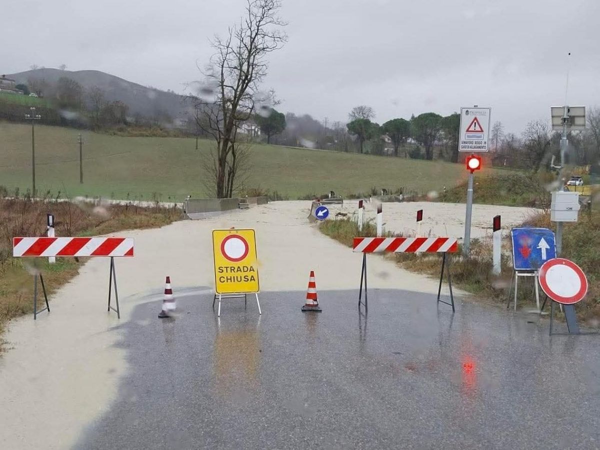
In Emilia-Romagna there is an orange alert
Some partial flooding of underpasses was recorded Bologna for bad weather. The Municipality reports this in an update note on the “orange weather alert”, underlining that “the update bulletin published by the Regional Civil Protection Agency and Arpae Functional Centre, valid from 10.30am until 3pm today, indicates that the rainfall of the last few hours is generating rapid rises in hydrometric levels of the Reno tributaries. They are expected for the next few hours widespread rainfall over the entire territoryof weak intensity on the westernmost sector and the northern plains, of moderate intensity on the remaining areas”. The civil protection of Emilia-Romagna has in fact confirmed the orange alert for almost the entire regional territory already in force today, 24 December. Red alert also tomorrow in the plains in the provinces not only of Bologna but also of Ferrara and Ravenna. Specially observed are the right-hand tributaries of the Rhine with a hilly supply. The one that currently causes the main concerns is the Idice. Flooding is possible. In the afternoon in the Bologna area due to the heavy and persistent rain and the continuing weather warning Saint Lazarus of Savenaan order was issued to evacuate the basement and basement floors in some areas of the Municipality. «It is absolutely forbidden to transit or stop near watercourses during floods and in potentially flooded areas, except for the time strictly necessary for evacuation operations» we read on the Municipality’s Facebook page.
An event postponed in Molise
The traditional Oratino Christmas fault, initially scheduled for today, December 24th, has been postponed due to bad weather. The heavy rains which in the last few hours have been affecting a large part of Molise have pushed the organizers to postpone the lighting of the large ritual fire for safety reasons. The new date set is Sunday 28 December, starting at 3.30 pm. If weather conditions permit, the village will come together again around one of the most eagerly awaited events of the Christmas period, capable of attracting residents, returning emigrants and numerous visitors every year.
The forecast for December 25th: the warmest Christmas in the last 5 years
After a disturbed Christmas Eve throughout the Centre-North and in other regions such as Molise, tomorrow, 25 December, will be a White Christmas in the mountains: lots of snow above 600-700 meters in the North and on the Tuscan-Emilian Apennines, above 1000-1200 meters on the rest of the ridge. Lorenzo Tedici, media meteorologist at -, confirms a different Christmas: it will be “white”, windy and less hot than the autumn-style ones of the last 5 years. Until the morning, the regions hit by the greatest rainfall will be those in the North-West and those in the Tyrrhenian area; during the afternoon we will still have open umbrellas in the Centre-North and snow in the North-West Alps and the Northern Apennines, with only some isolated phenomena in the extreme South. Tomorrow in the Emilia Romagna region it is expected red alert in the area of the Bolognese plain due to the risk of floods «on the tributaries on the right of the Reno with a hilly supply». The maximum alert also concerns the flat areas of the provinces Ferrara and Ravenna.
Arctic waves are coming
In the heart of winter, icy waves of Arctic origin can occur, very cold air masses which from the North Pole can push towards Europe and Italy, causing sudden drops in temperatures and it snowed all the way down to the plains. This happens when the polar vortex destabilizes due to intrusions of milder air at high latitudes, allowing freezing waves to reach Europe. According to the latest updates from Mattia Gussoni, meteorologist at -, three waves of frost are expected in the next ten days. At firstfrom December 29th, could lead to a marked cooling, but with mostly stable and sunny conditions. The secondbetween New Year’s Eve and New Year’s Eve, would bring a further temperature collapse, with possible snowfall at low altitude in the Centre-South, especially on the Adriatic side. The third, after January 2–3, could be the most intensewith freezing air up to the Mediterranean and a more eventful weather phase if it were to interact with an Atlantic disturbance. At the basis of this evolution is the stratospheric warming, a phenomenon capable of weakening the polar vortex (or vertex).the vast area of low pressure surrounding the Arctic. When this large reservoir of cold air is destabilized, the icy masses can escape more easily and descend towards lower latitudes, directly influencing the European and Italian climate.
December 24, 2025 (changed December 24, 2025 | 9:18 pm)
© ALL RIGHTS RESERVED


