July: the updated trend has just arrived with specific focus on precipitation and temperatures expected in Italy. We will tell you right away, there will be no shortage of surprises with our country that will find itself right in the middle of the battlefield between scorching flames of the African anticyclone and fresh and unstable currents descending from Northern Europe.
But let’s go in order. There First week of the month of July will be quite livelydue to the entry of yet another storm front descending from Northern Europe which will cause precipitation first in the North and then also in the rest of Italy.
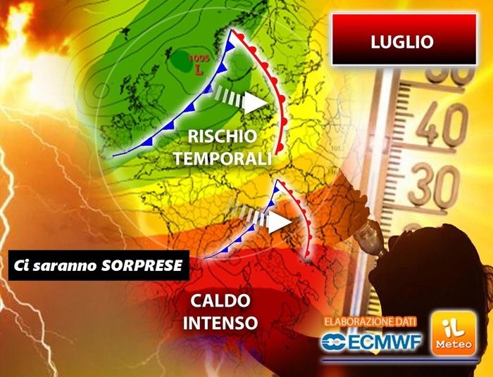
However, the latest updates have just highlighted a possible important turning point with direct consequences for Italy already by the middle of the month. Without a doubt the most important news concerns the field of temperatureforecast well above the climatic averages. It seems that from 10/7 onwards we will have to deal with very high values caused by hot air masses carried by the infamous African anticyclone arriving directly from the Sahara desert.
In practice this risks translating into heat waves with maximum temperatures ready to soar well above the 35°Cespecially in the Po Valley, in the internal areas of the two major islands (here you could even touch the 40°C) and on part of the Centre.
In particular, theentry of cold and unstable drafts at high altitude it could act as a trigger for the explosion, even sudden, of strong thunderstormsoften accompanied by hailespecially during the afternoon hours.
All these dynamics are part of the broader picture of ongoing climate change. According to a recent study, which examined data on climate evolution in Southern Europe, thus also including the Mediterranean basin and Italy, it emerged that from 1979 to today the energy in play (CAPE in technical terms: Convective Available Potential Energyi.e. available convective potential energy).
The cause of this increase can certainly be attributed to the increasingly constant and intrusive presence of the African anticyclone which determines an increase in average temperatures and, consequently, a greater evaporation of sea waterwhich then translates into fuel for high-intensity, sometimes even extreme events.
All this causes an increase in convective precipitation, the number of hours with thunderstorms and the number of hours with violent storms (hail large).
In short, here is one of the effects of ongoing climate change: two sides of the same coin, as the heat increases, the risk of violent storms increases.
By the middle of the month we will not rule out this danger and, according to the updated maps, the Northern regions could be at greatest risk due to the arrival of more unstable flows descending from the Atlantic.


