In this article we will try to find out how the month of May will behave in Italy, from a meteorological and climatological point of view. Like every month, we go to see what the meteorological models of the international computer centers suggest to us with the seasonal and monthly forecasts.
Before going into details it should be remembered how the seasonal forecasts, better known by professionals with the term of “trend lines”, they are experimental in nature and present uncertainties, but they are nevertheless instruments of high scientific value, especially from a future perspective.
They are not detailed weather forecasts of the weather on a certain day in a given location, but they give us the picture of what the climate trend of the future month could be, revealing to us in advance whether it will be warmer or colder than average, whether the climate will be drier or more humid.
What will May be like?
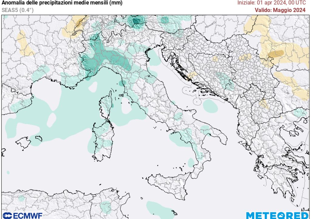
Taking the reference model of as a point of reference for our analyses Meteored, based on data from the European center ECMWFthe month of May could open with a certain dynamism, with the passage of various disturbances over Europe and the Mediterranean area.
This will be induced by the presence of negative pressure and geopotential anomalies over the western Mediterranean area, while further east, areas with pressure values above average will appear.
In Italy this will translate into decidedly more unstable weather, with rainfall slightly above average in the North, in particular in the North West, and along the Tyrrhenian sectors. In the northern regions there will be the risk of witnessing short but intense thunderstorms.
From a thermal point of view, however, we will have temperatures generally in line with the seasonal averages, or just above the south, causes greater exposure to siroccal calls from North Africa.
More stable second decade?
From the latest analysis processed by the model ECMWF we note how the second decade will be characterized by greater stability, for a temporary increase in geopotential values over Central Europe, while at the same time a negative geopotential and pressure anomaly will persist further west, on the Atlantic.
Cumulonimbus, the spectacular storm clouds

This baric structure could lead to the development of subtropical anticyclonic promontories on the central-western Mediterranean basin, but of limited duration in time.

The development of these promontories, fed by hot continental subtropical air rising from Western Sahara, it will lead to periods of more stable and sunny weather over the country, except for cooler and more unstable phases on the Adriatic and in the South.
Hot or unstable third decade?
The long-term signals are still not very clear, but from what can be seen the last part of May seems to be characterized by a more stable and sunny type of weather in the centre-north, with temperatures above the average for the period.

While in the south and in the middle and lower Adriatic area, a decline, albeit not marked, in geopotentials could pave the way for fresh secondary circulations from the Balkan area, capable of activating thermoconvective instability in the innermost areas of the Apennines.
Watch out for the famous spring storms
In the month of May the intensification of solar radiation and the progressive warming of internal areas may facilitate the development of thunderstorms, even very intense ones, especially in the Po Valley, where in certain meteorological situations dangerous situations can arise “superstorm cells”.
All the heat accumulated in the atmosphere can favor the development of thunderstorms, even quite violent ones, capable of causing hailstorms, intense rainfall and strong gusts of wind.
Similar storm events, typical of late spring, are produced as soon as colder air at high altitude, of oceanic or northern European origin, begins to flow above the layer of warm and humid air, which in the meantime has settled in the lowlands. layers.
Record hail all over the world, you will be surprised by the size recorded. Huge beans also in Italy

The strong thermal contrasts that arise between the lower layers and the higher layers of the troposphere can produce very strong turbulences, capable of generating imposing cumulonimbus clouds, harbingers of rain, hail and gusts of wind.


