
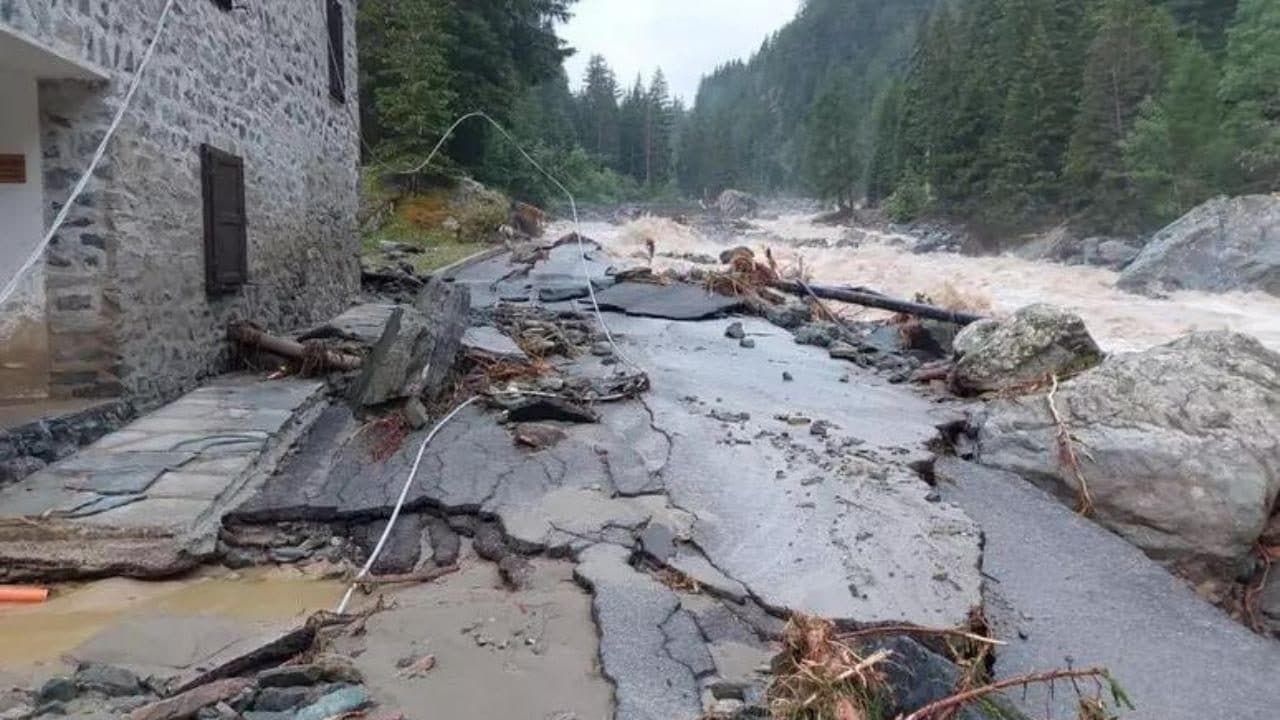
It has been declared state of emergency for the extensive damage caused by the very strong wave of bad weather which hit the on Saturday 29 June 2024 Valle d’Aosta and the Piedmontin particular Cervinia, Cogne, Canavese and the Lanzo Valleys, with violent downpours, floods, landslides, devastating hail, rivers of mud, cars sucked in by the current and descending gusts, fortunately all without causing casualties. In the Aosta Valley, the areas between Gran Paradiso, the Matterhorn and Monte Rosa were particularly hard hit, with Cogne and Cervinia remaining isolated due to the numerous floods. In Piedmont, the Orco Valley was hit by a landslide that isolated the upper valley and by a violent hailstorm (probably the worst in the area in the last 70 years) with hailstones up to 8 centimetres that ruined roofs and vehicles. Also in the Canavese, in Busano a probable downburst (downward gust) with winds up to 120 km/h blew the roof off a house. Another landslide in the Lanzo Valley isolated the town of Usseglio. Floods and landslides also occurred in Verbano, destroying entire roads. On Sunday 30 June, more than 500 people were evacuated, while bad weather also caused floods and damage in Canton of Ticinoin Switzerland. The bad weather has currently moved towards the North-East: the Civil Protection has established the weather warning in Friuli-Venezia Giulia, Veneto and Emilia-Romagna for thunderstorms and strong winds.
Was a exceptional meteorological eventeven though bad weather was forecast and the Civil Protection had declared a state of alert. What happened was caused by supercellethat is, violent thunderstorms that form in the presence of a rotating low pressure area. They are relatively rare thunderstorms but very dangerous from the point of view of the energy they are able to release. The thunderstorms were also self-regeneratingi.e. characterized by a vertical motion of the air masses, like a “suction” of air from low altitudes which, as it rises, cools thus providing a continuous formation of water vapor which maintains the dimensions of the storm cell and the intensity of the phenomenon stormy.
All this came about because two different air masses collided in the affected areas: at high altitudes there were currents of southwest (an energetic and humid wind coming from the southwest), while at lower altitudes a warm wind of sirocco coming from the south-east. The Sirocco entered the affected valleys, attracted by an area of low pressure coming from the Atlantic which, after having crossed Spain, was stationed in France beyond the Alps. All this happened at a time when the air at altitudes medium-low was extremely thermal energy charge, which on the one hand provides the “fuel” for storm phenomena and on the other makes the air full of water vapor available for precipitation. The clash of these two currents in one area extremely limited from the complex orography of the territory and with a very high density of thermal energy it was essentially like setting fire to a fuse: supercells were formed which self-powered thanks to the phenomenon of self-regeneration and had a large amount of energy to discharge very quickly in a very limited area.
To make the situation worse there was another factor linked to the thermal energy of the air: lo zero thermal (basically the minimum altitude where the temperature is 0 °C) was at approx 4000 metersso the mountains were covered with snow up to the peaks. The intense precipitation therefore did not encounter ice but snow, which with the rain became liquid and flowed down the valley, adding to the water that fell through the precipitation. All this water in turn caused the numerous landslides that hit the valleys.
What happened in Valle d’Aosta and Piedmont is therefore the result of the convergence of several factors that occurred simultaneously. However, this is not “simple” bad weather: these events are increasingly due to global warmingwhich increases the frequency and intensity of extreme weather events: let us remember that higher temperatures mean more thermal energy, that is, more “fuel” for the development of violent and destructive events such as those that increasingly fill the front pages of newspapers around the world.
