Perugia, 3 July 2024 – The Regional Council approved, in line with regional law no. 1/2015, on the proposal of Councillor Melasecche, for the delegation to mitigate hydraulic, hydrogeological and seismic risk, the resolution with which the regional register of geological singularities or geosites is updated, replacing map no. 11 of the 2000 Urban Territorial Plan which set the constraints for geological singularities.
This is an important act, explains the Councilor, given that the descriptive sheets of the areas under protection in our region date back to the 90s and do not take into account the technical definition of geosite which, at the time, was classified as a “geological singularity”.
It is important to underline that the revision work carried out by the regional offices has been indicated as an example at the national congress of the Italian Geological Society where it will be presented. Furthermore, the modification of the geosites register is made before the adoption of the regional landscape plan so that it is included in an updated form in the latter.
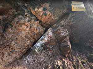
The update was necessary since, in the drafting of the mapping of the 90s, many areas, although of great interest, were defined as generic landscape type, thus placing them in a different band from that of geosite which instead is by definition recognized as a hypogean or underwater place, spatially limited and clearly distinguishable from the surrounding areas, with geological characteristics of intrinsic international, national or regional scientific interest that allow us to understand the history or geological evolution of a territory and for which it is possible to identify a geological interest for its conservation.
In light of the importance of giving due consideration to these sites, careful work has been carried out to draft the new regional register of geosites, placing 9 of them, unifying 8 of them and identifying 3 new ones for a total of 37.
From an areal point of view, on about 220 square kilometers there will no longer be the constraint as per the correct definition of geosite of the Higher Institute for Environmental Research and Protection (ISPRA). Furthermore, without imposing any constraint, the Geological Section directed by geologist Dr. Andrea Motti, whom I thank, has proceeded to frame the entire regional territory in 10 different domains of geological forms of the landscape in addition to creating the new geo-tourist itinerary Spoleto-Norcia.
The councilor concludes: “The timely attention to all aspects of safeguarding naturalistic and geological sites constitutes a constant of the regional policy in the context of sustainable development that Umbria pursues with conviction and commitment”
(0)
